Hendre
| Alternative name | Hendre No. 1 | ||||||||||||||||||||||||||||||||||||||||||||||||||||||||||||
|---|---|---|---|---|---|---|---|---|---|---|---|---|---|---|---|---|---|---|---|---|---|---|---|---|---|---|---|---|---|---|---|---|---|---|---|---|---|---|---|---|---|---|---|---|---|---|---|---|---|---|---|---|---|---|---|---|---|---|---|---|---|
| Location | SH614254 (Area map showing location.) | ||||||||||||||||||||||||||||||||||||||||||||||||||||||||||||
| Parish | Llanbedr | ||||||||||||||||||||||||||||||||||||||||||||||||||||||||||||
| Geology | A bed about .38 m thick of mixed carbonate and silicate of manganese interstratified with the Harlech grits on the flanks of Moelfre hill. The ore contains 30–32% manganese. [Dewey & Bromehead 1915: 51] | ||||||||||||||||||||||||||||||||||||||||||||||||||||||||||||
| Owners |
| ||||||||||||||||||||||||||||||||||||||||||||||||||||||||||||
| Worked | 1889–1904, 1917, 1918, 1920 | ||||||||||||||||||||||||||||||||||||||||||||||||||||||||||||
| Production and Employment |
|
||||||||||||||||||||||||||||||||||||||||||||||||||||||||||||
| Transport | |||||||||||||||||||||||||||||||||||||||||||||||||||||||||||||
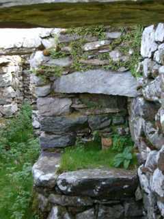
| Remains | At lowest level of mine are several large modern(?) adits (which may be mineral trials). There is a smithy with a hearth and chimney and a small inner room with a domestic hearth. Higher are small levels, some run-in or partly run-in at their entrances, leading to worked-out chambers with pack walling. These levels are approached by walled cuttings through waste tips and in some cases have low loading banks adjacent to the access tracks. Above these levels is a long stretch of shallow opencasts continuing up mountain. (September 2002) | ||||||||||||||||||||||||||||||||||||||||||||||||||||||||||||
Known as Hendre No. 1 mine to distinguish it from Hendre No. 2, a gold mine 5.6km from Trawsfynydd.
Hendre is recorded in 1889 under the Harlech Mining Co. Ltd. It seems to have done little work and following the dissolution of the company in October 1892 the mine was taken by James Macqueen under a take-note from the Crown dated 24th March, 1890. Macqueen spent £1685 on the mine, raising £1065 from sales of ore but on 14th October, 1891 he decided to sell out to the Dyffryn Mining Co. Ltd (of which he was a director) to enable it to be worked with their existing mines. If the sale went through, it never reached the official records. The mine closed in 1893, being re-opened in 1898 by F B Haigh and William Simon who (either or both) operated it until 1904 when it was closed. The operations were transferred to nearby Moelfre mine. Probably about 1914 Hendre was re-opened and the bed was followed to a considerable depth during the war but, by 1923, the remaining operations were largely opencast and no doubt ceased soon afterwards [Down 1980: 39].
Although the above account suggests that the mine was inoperative 1905–1913, W Bowen-Jones notes that in 1905 one man was employed “raising manganese ore” [GAS CAO: XD/35/420 p. 70]. (In the next diary entry, headed Rallt Fawr 24 February 1905, the Inspector notes “Licencee intends to give Hendre up in July and then work at Rallt Fawr.”)
In 1917 nine men were employed for at least three months opening out one of the levels in the old workings and making surface excavations on the bed of manganese ore further up the hillside. Some ore was taken away. [GAS CAO: XD/35/424 p. 161] In November of that year Thomas Griffiths was reported as having died from injuries received during blasting operations at the mine. Griffiths was sheltering (with a man named Foulkes) during blasting when a flying piece of stone struck him on the forehead. [Llangollen Advertiser 9th November 1917 p. 5]
The mine was described as “active” in 1923 [Dewey & Dines 1923: 66].
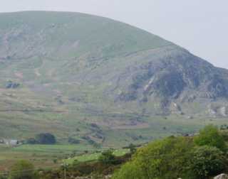 |
General view
Looking south-west from SH640278 towards the north side of Moelfre mountain The workings can be seen (more clearly in the enlargement) running upwards and rightwards from the area of tips slightly left of the centre of the picture to converge with the wall that runs across the flank of Moelfre. |
|
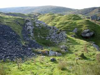 |
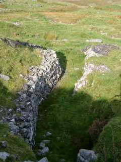
Tip with Revetment
Purpose unknown, possibly a high loading bank? The track to the right of the tip leaves the main mine track via a bridge over the stream (behind viewpoint) and climbs round and across the top of the tip to the smithy. The hill in the background is Moelfre. |
|
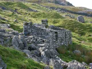 |
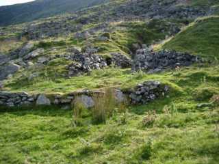
Smithy
View from east. Note tips in background. |
|
 |
Smithy
North west elevation. The back wall of the smithy aligns with the right hand side of the chimney stack. The apparent elevation of the building to the right of the door is a solid masonry infilling between the back wall and the slope. |
|
 |
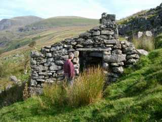
Smithy Hearth
View through the doorway visible in the previous picture. The hearth is approximately 3' (.9m) square. The chimney lintel spans from a wing wall (which forms the side wall of the hearth) to the rear wall of the smithy. Facing the viewpoint in the side wall of the hearth is a brick-surrounded hole which may have been where the draft from the bellows was brought to the hearth. To the left of the hearth can be seen the doorway leading into a small room, possibly an office, at the far end of the smithy. This room has a domestic hearth in the corner opposite the doorway. To the right of the hearth, just below the level of the chimney lintel, can be seen a small recess in the back wall of the building, purpose unknown. |
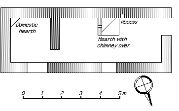 |
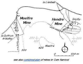
Plan of Smithy |