Moelfre
| Alternative name |
Moelfra Llanenddwyn? Rallt Fawr [GAS CAO: XD/35/422 p. 74] |
||||||||||||||||||||||||||||||||||||||||||||||||||||||||||||||||||||||||||||||||
|---|---|---|---|---|---|---|---|---|---|---|---|---|---|---|---|---|---|---|---|---|---|---|---|---|---|---|---|---|---|---|---|---|---|---|---|---|---|---|---|---|---|---|---|---|---|---|---|---|---|---|---|---|---|---|---|---|---|---|---|---|---|---|---|---|---|---|---|---|---|---|---|---|---|---|---|---|---|---|---|---|---|
| Location | SH613248–SH615258 (Area map showing location.) | ||||||||||||||||||||||||||||||||||||||||||||||||||||||||||||||||||||||||||||||||
| Parish | Llanenddwyn | ||||||||||||||||||||||||||||||||||||||||||||||||||||||||||||||||||||||||||||||||
| Geology | A bed about .38 m thick of mixed carbonate and silicate of manganese interstratified with the Harlech grits on the flanks of Moelfre hill. The ore contains 30–32% manganese. [Dewey & Bromehead 1915: 51] | ||||||||||||||||||||||||||||||||||||||||||||||||||||||||||||||||||||||||||||||||
| Owners |
|
||||||||||||||||||||||||||||||||||||||||||||||||||||||||||||||||||||||||||||||||
| Worked | 1835–1840, 1886–1892, 1901, 1905–1913, 1915–1917 | ||||||||||||||||||||||||||||||||||||||||||||||||||||||||||||||||||||||||||||||||
| Production and Employment |
|
||||||||||||||||||||||||||||||||||||||||||||||||||||||||||||||||||||||||||||||||
| Transport | Internal tramway. Cartage to Llanbedr station [Dewey & Bromehead 1915: 51] | ||||||||||||||||||||||||||||||||||||||||||||||||||||||||||||||||||||||||||||||||
| Remains | Number of underground and surface workings, loading banks and possible building remains. Trial levels. (June 2002) | ||||||||||||||||||||||||||||||||||||||||||||||||||||||||||||||||||||||||||||||||
| Access | The northern end of the workings are adjacent to a public road and a public right of way crosses the southern end of the site. | ||||||||||||||||||||||||||||||||||||||||||||||||||||||||||||||||||||||||||||||||
Worked for oxide 1835–1840 [Down 1980: 39]. Restarted November 1885.
In 1910 two men were employed underground. The rent paid at that time for ffridd (owned by Capt. Gwyn Jones) where the workings were was £30 for 33 acres i.e. 3/- (£0.15) per acre, possibly on a 30 year lease. The ore was worth 23/- (£1.15) per ton at Dyffryn station and the cost of cartage to the station was 3/- (£0.15) per ton. [GAS CAO: XD/35/422 p. 74]
In 1915 one or two men were employed for a short period in the old workings and some ore was removed [GAS CAO: XD/35/424 p. 128]. (Dewey & Bromehead [1915: 51] describe the mine as “abandoned” about this time.)
In September 1917 three men were employed mining ore and opening out the bed in new ground. Four or five men had been employed (possibly earlier in the year) driving a short level into the manganese bed and about 30 tons of ore were extracted and sent away by A R Mason who was in charge of operations at that time. [GAS CAO: XD/35/424 p. 161]
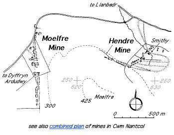
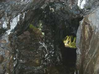
The Dyffryn Mining Co. mine abandonment plan of February 1887 [GAS DAO: 2301B] shows a number of features around SH612254 including what appears to a tramway (shown on a section only), a section showing small-scale localised folding worked by two sets of branching adits at various levels, two other underground workings and the gold level. Level No 1 (as shown on the plan) is still enterable but terminates after a short distance in a collapse from the surface. Levels No 2, 3 and 4 appear to have been closed by collapse of their entrances, although the walled cuttings leading to them are visible on the ground. The gold level is enterable.
North of the area covered by the abandonment plan are further underground workings (see photos below), presumably post-February 1887, and another trial level which appears to have been broken into at its inner end by a manganese working above it.
There are also signs of mining further up the hill to the east of the main area near SH617255.
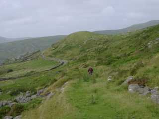 |
General view of mine
Looking north from SH614253 on the occupation road (the grassy track in the foreground). The workings extend from some distance behind the camera to just beyond the point where the tarmac road disappears round the hill. The area covered by the mine abandonment plan is to the right of the occupation road beyond the standing figure. |
|
 |
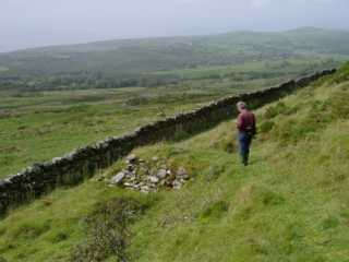
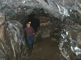
Gold Level
The gold level (so called on the abandonment plan). Down [1980: 41] suggests that it dates from the 1850s. This is a substantially straight level with no significant development. It terminates just beyond what appears to be a fault where a small amount of water enters the working. This level and the other trial level further north are below the level of the manganese outcrop. |
|
 |
Loading bank
Loading bank above road at SH615256. |
|
 |
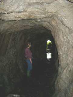
Underground working
Looking north towards the entrance. The passage runs parallel to and very close to the surface. Most of the west (left hand) wall consists of pack walling and it appears that the working was developed from the surface along most of its length and then walled up as it became deeper. |
|
 |
Underground working
Looking south along the working from approximately the same location as in the photograph above. Again, note how the west (right hand) wall of the passage is pack wall. |