Harlech
| Alternative names | Llechwedd Du see below Llechwedd Goleu Ty Newydd ? [GAT SMR: 20534] |
||||||||||||||||||||||||||||
|---|---|---|---|---|---|---|---|---|---|---|---|---|---|---|---|---|---|---|---|---|---|---|---|---|---|---|---|---|---|
| Location | SH592319 (Area map showing location.) | ||||||||||||||||||||||||||||
| Parish | Llandanwg | ||||||||||||||||||||||||||||
| Owners |
|
||||||||||||||||||||||||||||
| Production and Employment |
|
||||||||||||||||||||||||||||
| Transport | Road to Harlech station (or possibly a siding – see below) | ||||||||||||||||||||||||||||
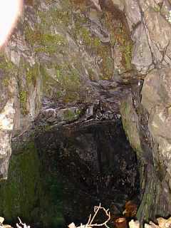
| Remains | Walled-up and gated bedding by the side of B4573 at SH59263194. There is an open entrance at SH59223187 behind and above the corrugated iron garage shown in the photograph below. Other entrances appear to be blocked or have run in. There is manganese mining waste on slopes below the entrances. (July 2003) | ||||||||||||||||||||||||||||
|
The names Llechwedd Ddu and Llechwedd Golau are problematical. Wilkinson [2002: 14278] and [GAT SMR: 21833] give a location of SH604333 for Llechwedd Ddu mine, which is the same location as Lletty’r Wialch. Down [1980: 30] suggests that from its name Llechwedd Ddu mine was located near Llechwedd-du-bach farm (SH59653233) where the manganese bed outcrops. However, there is also a Llechwedd-du-mawr farm at SH60173292 which is just south of Lletty’r Wialch so this is not conclusive.
Down makes an alternative suggestion based on the evidence of ownership records and output statistics that Llechwedd Ddu mine may be the same mine as Harlech. W Bowen-Jones [GAS CAO: XD/35/420 p. 94] refers to Llechwedd Mine Harlech and states that men were employed “on the lower side of the road on Lletty Perig land belonging to Mr Holland”. Samuel Holland was the land owner at Llechwedd Du in 1886 (although he did not enjoy the mineral rights which were retained by the Crown [GAS CAO: XD/8/4/890]). Giffin [2003] suggests that ‘Lletty Perig’ may refer to the house at SH59153183 on the B4573 north of Harlech named ‘Lletty Perygl’. Considering the number of property names that include ‘Lechwedd’ in the vicinity of Harlech mine, it would seem that the whole area around Harlech mine has been known as Lechwedd at one time or another. Consequently, Down’s suggestion that Llechwedd-du is the same mine as Harlech appears to be well-founded and on this basis Llechwedd Du has been included in this entry. |
The plan (two similar sheets, one of which is sub-titled “Levels Nos 1 & 2”) shows at least five entrances into an extensive area of pillar and stall working, with many of the pillars subsequently worked out. One of the plans shows a “cabin” near the entrances. The location of the mine cannot be identified from the plan, however, it is not inconsistent with the remains described above.
Halse [1887: 108] records that carting the ore to Harlech station cost 9d (4p) per ton and that the greatest profit was only about 6d (2.5p) per ton due to faults and the low grade of the ore (27% manganese).
[Groves 1952] reports the possible existence of a siding on the Cambrian Coast railway line at the nearest point to the mine, but this is not verified. The 25" map [OS 2nd edn 25" XIX:13] shows a siding extending northwards from the Harlech station loop for aproximately 250 m, on the east side of and parallel to the main line. Another possibility is that the 1:25,000 map [OS 2000] appears to show a widening of the railway formation at SH58803267–SH58943284 that might have accommodated such a siding, although there does not seem to be any road access to this point.
In 1905 two men were employed for a few days clearing the level “on the lower side of the road on Lletty Perig land” [GAS CAO: XD/35/420 p. 94].
ICI geologists connected with the explosives manufactory at Penrhyndeudraeth surveyed this site in 1959 [Brown 2002]. Some underground workings are now reported to be inaccesible following collapses [Morris, Harold 2002, pers. comm.].
 Photograph © John Ruston 2000 |
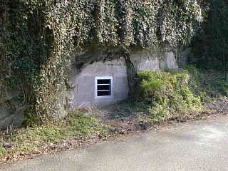
Walled-up entrance with bat access close to road edge
SH59263194 The wall which closes the entrance was built in the 1980s after the road collapsed into the mine. Other entrances exist above and to the south of this in densely overgrown woodland. Local residents recall wire ropes and pulleys lying as scrap at the foot of the hill [Ruston 2000]. The gate is padlocked (key-holder unkown). |
||
 Photograph © John Ruston 2000 |
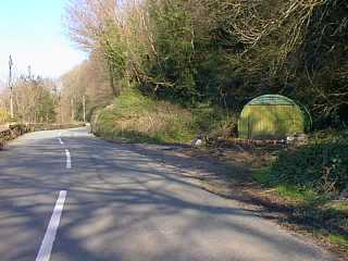
Collapse area
An earlier collapse is marked by a lay-by (small Nissen hut style corrugated iron garage on private land), 100 m south-west of walled-up entrance above. It is reported that over-enthusiastic ‘quarrying’ for ballast by council workers ended when one of their machines disappeared into the stopes [Ruston 2000]. There is an open entrance behind and above the garage. |
||
| Adit in quartz vein SH589319 Short (~ 4m) adit driven at sea-level apparently on a quartz vein. Considering its position it is probably not associated with manganese. It is possibly a trial for metals. Access: Footpath with sign “National Trust Coed Llechwedd” opposite entrance to Woodland Trust reserve, 100yards north of Erinfa (a large detached house associated with Robert Graves). Follow zigzag path to foot of the hill though brambles and fallen trees) |