Lletty Walter
| Alternative names |
Artro ? Harlech Lletty Lletty [GAS DAO Z/DAM/630] renamed 1890 as Coed or “Llanbedr, lately Coed” see also Coed In 1915 referred to as “Lletty Walter and Artro” [Dewy & Bromehead 1915: 50] |
||||||||
|---|---|---|---|---|---|---|---|---|---|
| Location | SH604278 (Area map showing location.) | ||||||||
| Parish | Llanbedr | ||||||||
| Geology | A bed of carbonate, with some silicate, of manganese. The carbonate and silicate are in part weathered to pyrolusite. The ore contains about 22% metalic manganese. The bed is ~.56 m in thickness dipping gently eastward and is interstratified with the Harlech grits and conglomerates. [Dewey & Bromehead 1915: 50] | ||||||||
| Owners | see Coed, see also Artro | ||||||||
| Worked | 1869–1878, 1886–1891 see also Coed | ||||||||
| Production and Employment |
|
||||||||
| Transport | Short tramway to loading point on Cwm Bychan road. Cartage to Llanbedr station (~2.4km) [Dewey & Bromehead 1915: 50] | ||||||||
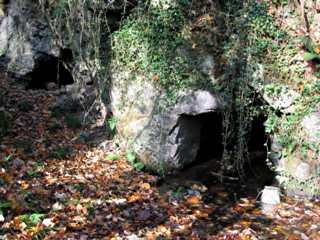
| Remains | Overgrown by woods. Some rubbish dumped by and just inside adit entrance near river. This adit runs approximately due north for 60 m up the east side of the stoped area and shows shot hole remnants. There is approximately .8 m depth standing water and soft mud for the first 20 m or so. The river bank near this adit entrance has been built up with waste. Close to the road is an entrance, partialy blocked with rubbish, to an east-aligned passage through stacked waste. Loading bank at roadside at SH60422787. There is a hole (blocked with rubbish) in the field on the other side of the road to the mine, possibly associated with the north-western corner of the stoped area shown on the plan. With the exception of the passages mentioned, most of the stoped area shown on the plan above has been filled with stacked waste. To the imediate south-west of the stoped area on the plan is an area of what may have been surface working. (November 2003) | ||||||||
In 1915 the workings were referred to as “Lletty Walter and Artro” and described as abandoned. They included two 60yd levels. It was reported that the ore was sent to St Helens for use in glass manufacture [Dewy & Bromehead 1915: 50].
A feature of the bottom-level adit is that it appears to pass though a large fissure filled with a fluvial-glacial deposit of rounded cobbles in a gritty matrix. This has partially run-in to the adit at one point leaving a void under an unsuported roof of the cobble fill.
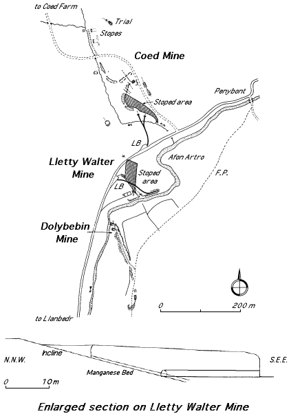
The plan and enlarged section (right) are based on the 1887 abandonment plan for Dolbebin mine, surveyed by Edward Stables) [GAS DAO: 2125].
The plan right is incorrect in that the alignment of the Dolbebin mine workings and track that descend to the river is approximately N.N.E. - S.S.W. rather than as shown currently. A corrected plan will be shown in due course.