Diphwys
| Alternative name | Old Diphwys Diffwys |
||||||||||||
|---|---|---|---|---|---|---|---|---|---|---|---|---|---|
| Location | SH667235 (Area map showing location.) | ||||||||||||
| Parish | Llanelltyd | ||||||||||||
| Owners | Dyffryn Mining Co. 1886–1887 | ||||||||||||
| Worked | 1886–1887 | ||||||||||||
| Production and Employment |
|
||||||||||||
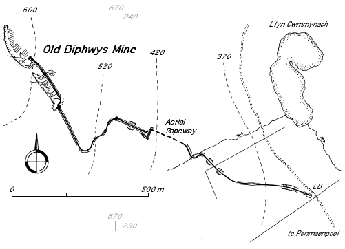
| Transport | The workings were served by an incline on their northern side. From this a second incline descended to a near level tramway for 200 m, in places on a substantial dry-stone causeway. This led to a third incline followed by an aerial ropeway. At the bottom of the ropeway was a tramway for 800 m with drystone causeways and cuttings to a loading point at SH68002321 on the cart track up the west side of Cwm Mynach. (This track was originally developed to serve the Cefn Gam slate quarry [Richards 1991: 156].) | ||||||||||||
| Remains | The workings extend from SH66722355 to SH66652380 and appear to have followed the bedding down dip (~60°) with a number of strike alligned adits. However, the workings have been covered by the collapse of the headwall and the adit entrances, such as at SH66722369, have run in. There are extensive waste tips with some walling. Sheave base at summit of lower incline at SH66992357. Head of aerial ropeway at SH66152552 with iron eyes set in rock, base for support tower, masonry jetty and rock cut away for clearance of ropeway run. Bottom landing of ropeway at SH67312347 with iron eyes set in the rock and low wall. | ||||||||||||
| In addition to the obvious mine and tramway related remains there is a stone-built structure composed of four adjoining 1 m x 6 m cells with walls up to 1 m high on down-hill side, overgrown by heather, purpose unknown (possibly foundations for a barracks), at SH67302350, and a small (3 m x 2.5 m internal) dilapidated building close by. There are dilapidated buildings at SH67452335 (2 m x 2 m internal, marked as ‘Magazine’ on the 1887 6" map [OS 1st edn: XXXII NE]) and SH67352337 (3 m x 3 m internal) which are probably connected with the mine. | |||||||||||||
| Access | The course of the tramways and inclines is accessible from the track up the west side of Cwm Mynach. They can be followed, initially through forestry, up the mountain to the mine workings at around 600 m altitude. Although not a right of way, the disused tramway is shown as a path on 1:25,000 [OS 2000] and 1:50,000 OS maps. (April 2003) | ||||||||||||
Although the records show no output from this mine, the number of men employed and the extent of the waste tips suggest that a substantial amount of material was mined here [Down 1980: 49].
The tramway is shown on the 6" map of 1887 [OS 1st edn: XXXII NE], however, the 1901 revision [OS 2nd edn: XXXII NE] marks the course of the tramway as “Old Tramway” with no track shown so presumably it had been lifted by that date.
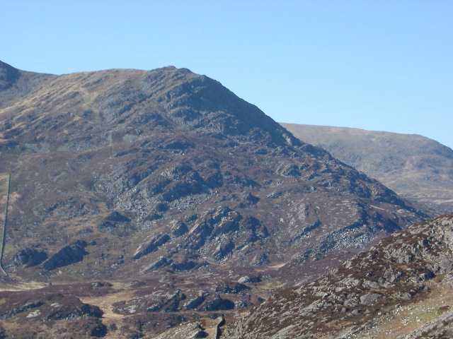
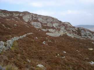
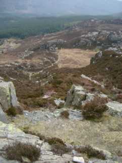
Looking NNW from SH677216. The mine is situated just below the skyline of the shoulder of Diffwys (top centre), and runs downwards and to the left following the visible line of the strata. The summit of Diffwys is just out of sight to the left of the picture.
 |
Workings
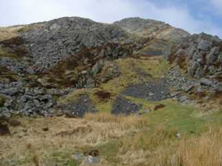
General view of workings from summit of middle incline. The workings extend almost to the skyline. The remnants of the worked out bed can be seen on the left with the waste tips in the centre of the picture. The top incline serving the various levels of the mine runs up the right hand side of the waste tips. |
|
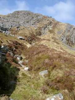 |
Upper workings
A closer view of the upper workings which can be seen in the distance in the previous photograph. |
|
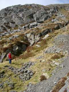 |
Waste tips
Waste tips with some walling. Beyond the standing figure is a cutting which leads to what is probably a run-in adit. |
|
 |
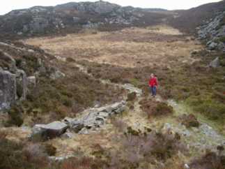
Middle incline
Looking down the middle incline from just below its summit. The line of the tramway continues round the shoulder on the left of the picture towards the summit of the bottom incline. |
|
 |
Tramway from bottom of middle incline to top of bottom incline.
In the distance can be seen the summit of the bottom incline which descends to the right of the picture. The causeway for the bottom incline is about 2 m wide. |
|
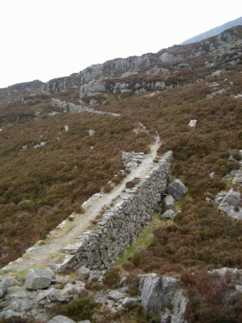 |
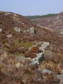
Causeway on tramway from bottom of middle incline to top of bottom incline.
Looking back along the line of the tramway visible in the previous photograph from just above the summit of the bottom incline at SH66992357. The causeway is about 2.5 m high where the ground is lowest and has vertical sides. |
|
 |
Ropeway head
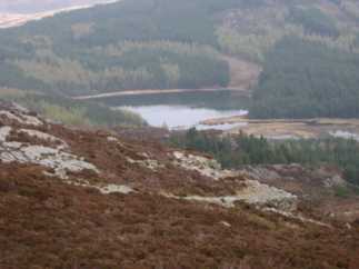
The bottom incline decends to the ropeway head from the left of the picture. Above the masonry structure of the ropeway head end and aligned with the ropeway is what is apparently the base for the ropeway support tower and two iron rings which were presumably anchors for the suspension ropes which ran over the tower. Llyn Cwm-mynach can be seen in the distance. |
|
 |
Ropeway takeoff
The takeoff point for the ropeway at SH66152552. The rock has been cut away to provide clearance for the ropeway. The ore could either have been transfered from tramway wagons to a skip on the aerial ropeway or else the wagons themselves could have been suspended by chains from a travelling carriage. In the distance beyond the clearance cutting can be seen the bottom landing of the ropeway with the line of the tramway running away from it and winding round the rock outcrops before running in a straight line towards the forrest. |
|
 |
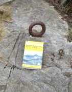
Ropeway foot
The bottom landing of the ropeway at SH67312347. Note the two iron rings set into rock which presumably were the anchors for the bottom end of the ropeway. The spacing of the anchor rings suggests that there may have been two suspension cables with two ropeway carriages operating as a balanced pair. Left of centre on the far side of the flat area can be seen the dilapidated structure at SH67352337 which may be associated with the mine, perhaps a hafodty reused as a barracks. |
|
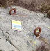  |
Ropeway anchors
Ropeway anchor rings at head (left) and foot (right) of ropeway. Iron rings, aproximately .12 m external diameter, on a shank set in a drilled hole which has then been filled with lead. Used to anchor the ropeway suspension ropes. Although rusty, they show little sign of wear which suggests that the ropeway was not in existence for very long. |
|
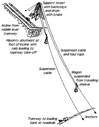 |
Conjectural arrangement of ropeway
The ropeway probably had two suspension cables running from the anchor rings behind the tower, over the top of the tower and down to the anchor rings at the bottom landing. The anchors at the bottom landing are spaced apart to provide sufficient clearance between the suspended wagons as they pass at mid-span. Each suspension cable would have had a travelling sheeve or carriage running on it. The travelling sheeves would have beenn connected to each other by a cable passing over sheeves in the tower. There would probably have been a sheeve or winding drum with a band brake to control the speed of descent of the loaded wagon. The wagons would have been suspended from the travelling sheeves by chains hooked to the wagon corners.
|
|
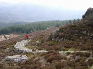 |
Masonry tramway causeway
Curved masonry tramway causeway at SH67402343. One of the number of masonry causeways on the bottom section of the tramway. Behind the standing figure the tramway continues in a near straight line across the hillside and through the forestry plantation to the loading bank. |
|
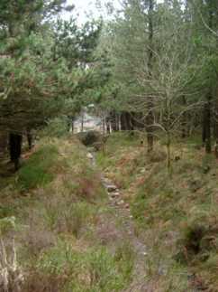 |
Cutting
Tramway route in a shallow cutting. The Cwm Mynach track can just be seen in the distance beyond the fallen tree. |
|
 |
Loading bank
The loading bank by the Cwm Mynach track at SH68002321. The bottom end of the tramway system. The line of the tramway is behind the standing figure into the forestry plantation. There are a number of pieces of bluestone waste scattered here, including a sizeable piece aproximately .25 m x .23 m x .15 m. |
|
 |
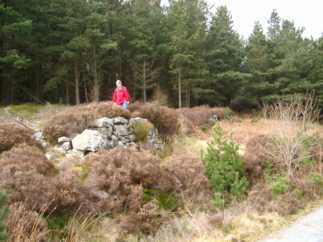
Masonry structure
The structure and associated(?) building at SH67302350. There are four cells, each approximately 6 m x 1 m, arranged in a two by two formation. The walls on the downhill side are aproximately 1 m high. The building behind them is aproximately 3 m x 2.5 m internal. Gwyn [1998] describes these as settling tanks. However, there are no obvious signs of a water course or launders leading to them. An alternative explanation is that they are the foundation of a wooden building, similar to the presumed barracks foundations at Rhinog. |