Cilcychwyn
| Location | SH630266 (Area map showing location.) | ||||||||||||||||
|---|---|---|---|---|---|---|---|---|---|---|---|---|---|---|---|---|---|
| Parish | Llanbedr | ||||||||||||||||
| Owners |
|
||||||||||||||||
| Agent | 1890–1891 Mrs H L Haigh | ||||||||||||||||
| Production and Employment |
|
||||||||||||||||
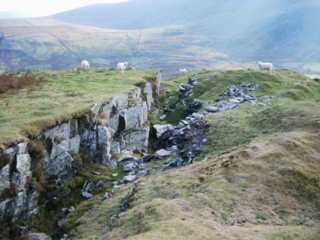
| Transport | An internal tramway, in places on a dry-stone embankment across a steep hillside, from the northern end of the mine at SH63052712 to a loading bank at SH63022679 [OS 1st edn: XXVI SE (1887)]. There was a later incline from SH63022656 down the hill serving the southern underground workings (with a bridge by one of the adit entrances), connecting with (or continuing as) a further incline down to near road level at SH63302640 followed by a track to the parish road at Pont Cerrig SH63422628. [OS 2nd edn: XXVI SE (1900)] | ||||||||||||||||
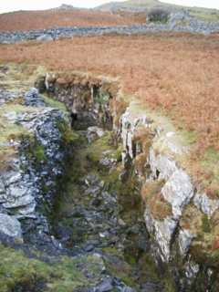
| Remains | A number of short adits leading to interconnected worked out chambers with fine examples of walled-up deads. Open workings with deads stacked on the west side of the working away from the working face. There is a small (now roofless) shelter of 2 m x 1 m internal dimensions constructed from waste in one of the open workings at SH63032677. Possible smithy SH63362633. (October 2003) | ||||||||||||||||
| Access | Most remains are close to, and accessible from, Public Rights of Way. | ||||||||||||||||
The lowest chamber of the series of workings going up the hill has been stoped out to 1.25 m wide in the bed dipping at 25°.
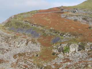
At the top of the hill, in addition to the underground workings, there are two parallel surface workings suggesting that either three separate manganese beds existed at this point or there is significant local folding or faulting bringing the bed to the surface in three places.
The two separate tramways shown on the 1887 and 1890 6" maps, [OS 1st edn: XXVI SE] and [OS 2nd edn: XXVI SE] respectively, suggest that the southern underground workings were a later (post-1887) development following exhaustion of the workings higher up the hill. It is possible that the incline serving this development re-used the earlier tramway materials.
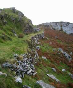 |
Tramway embankment
Looking south along the tramway embankment from near SH63042686. |
|
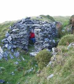 |
Shelter
Small shelter, now roofless, in open working at SH63032677. The shelter is constructed from waste and is approximately 2 m x 1 m internal dimensions. The figure is seated on a ledge (presumably constructed for that purpose) and in the wall oposite the ledge there are recesses which might have been used for food storage. The roof was possibly turf laid on boards. |
|
 |
Opencut working
The western of the two parallel opencut workings near SH632266. |
|
 |
Opencut working
The eastern of the two parallel opencut workings near SH632266. The left (western) wall of the working in the picture is composed of stacked waste. |
|
 |
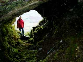
View of workings on incline
Looking north from SH633262 (near Pont Cerrig). The workings can be seen as a line of entrances running upwards and leftwards from the lower right of the picture, above the characteristic bluish tips of waste material. There is an incline in front of the entraces. The tramway formation and the opencast workings seen in the previous picures are out of sight over the skyline. |
|
 |
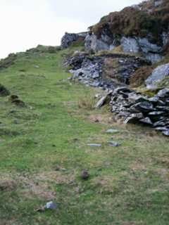
Incline and bridge abutment
The incline that served the workings on the steeply sloping outcrop. (Down’s plan [1980: 38] and reproduced above does not show this incline.) Depressions probably indicating the positions of sleepers are visible. The bridge carried the incline over the (presumed) tramway from one of the levels (out of sight on right of picture) to its tip and connection to the incline. |
|
 |
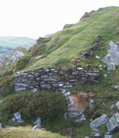
Incline and walled-up waste stacks
Further down the incline. Note walled-up stacks of waste rock which are adjacent to the adit entrances. The bridge abutment shown in the previous picture is just beyond the prominent waste stack on the sky-line (which was the viewpoint for that picture). |
|
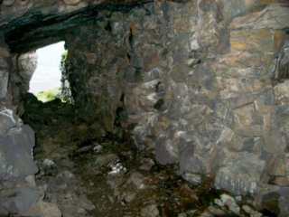 |
Pack wall in adit
The ‘adit’ has been created by walling up waste rock to support the roof and provide a clear access to the working face. |
|
 |
Adit
Looking out of the entrance of the lowest adit. The right-hand wall is packed waste. The roof follows the angle of dip. |
|
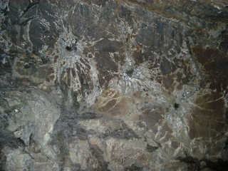 |
Shot Holes
Working face at end of adit. Note remnants of shot holes with cracks radiating from them. |
|
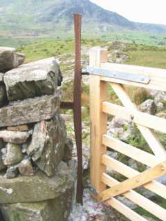 |
Fish-belly rail gatepost
This gate at the botom of the track leading up to the mine from the Cwm Nantcol road (SH63402627) has a gatepost and gate stop made from pieces of wrought-iron fish-belly rail. |
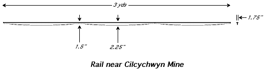
The drawing shows the length of rail as it was in December 2001 when it was positioned across the gateway mentioned above. The rail is possibly Birkinshaw’s rolled wrought-iron rail from his Bedlington Ironworks. Gwyn [2001] suggests that it has probably been cut down from an original length of 15' or 18' and that it probably came from the Ffestiniog Railway (or, in order of decreasing probability, Nantlle, Gaewern Quarry in Corris or Glynrhonwy). He reports that other pieces of similar rail can be seen in the Harlech Dome area. Gaewern seems a likely candidate as a number of similar rails have been found there in recent years. [Waite 2009] Gwyn questions as to when the local manganese workings developed to such an extent that railways were required. If the only track available second-hand was fish-bellied, was it earlier than 1886? (According to Boyd [1975: 373–7] the Ffestiniog Railway had replaced this type of rail by 1856.)